Rides & reports of motorcycle adventures..

5/12/13

Moab 5/13


Moab is a classic off road riding area.  The views are spectacular, & the terrain varies.  It can be very challenging, to pretty easy.  It's only about a 6 hr ride for me to get there, so a few years back i decided i'd add moab to my annual riding list.  Last year, we had a group ride planned, but the day we were to leave, some of the guys saw that there was a storm brewing in the west, & canceled out.  I went by myself, & got a couple of days of riding in before the rain hit.  Kim was the  mover & shaker this year, & had several neighbors & road riders who wanted to come.  Most of them i did not know, and had not ridden with.  But we had several months before the ride, so there was time to ride together on warmup rides, & make sure everyone was good to go in moab.

Kim made the hotel bookings for us.. we stayed at the Big Horn Lodge.. a nice hotel centrally located in town.  One of the guys, Ken, wanted to ride up on his new triumph tiger, so i rode up with him.  The other guys trailered up.  We left on Monday, May 5th.  There was another storm coming into the area.  It was sprinkling when i loaded up my gear, so i made sure i had all my rain gear with me, & waterproof gloves & boots.  Ken & i met in uptown Sedona ~ 9am, & rode up the canyon.  It was chilly through flagstaff & over the mountains in monticello, & we got a bit of rain here & there, but it was a great ride through the reservation & monument valley.

We all got into moab in the early afternoon, & checked into the hotel.  Chuck wanted to do a short ride through arches nat park.  So a few of us suited up & rode out.  It was still pretty chilly from the rains, & there was more in the forecast, but Chuck wanted to ride a dirt section he saw on a map that cut from inside the park back to the highway.  Mark & Ken were camping, so they stayed to set up camp.  That left 5 of us to ride.


We rode up through the park, then turned on a dirt road next to this view area.  After a couple of miles, it started to get sandy.  I felt the back end wobbling around through some of the sections, then came upon Chuck, with his Versys on top of him in a sandy wash.  A couple of us lifted the bike off, & helped get it upright.  Bob had gone back, since he only had his mesh jacket with him, so that left Kim, Chuck, Cliff & I as the riders.  After this mishap, Cliff decided to go back, too, so 3 remaining riders pressed on.  I brought up the rear, & rode about 1/2 mile until i met Kim & Chuck coming back.  They pointed to the rain in the distance, so i turned around, too.  Within a mile, it was sprinkling again, & in a short time was raining heavily.  But we all made it back, dried off, & met at the micro brewery for dinner & beer.

Kim had asked me to set up the rides for the 3 days of riding.  He wanted one of them to be a very easy ride, to gauge the abilities of the riders.  No one went on any of the pre ride warmups we planned in the earlier months.  They only wanted to do easy cream puff rides, so that is what they did.  So i planned the first one to be up gemini bridges, which had some fairly easy hills & winding around, with rocky sections.  The second day was to be the white rim trail, the signature ride of moab, & one of the most spectacular motorcycle day rides in the world.  The last day was to be onion creek, a fairly easy ride winding along a creek.

We met for breakfast at the adjacent diner, & planned the day.  It had rained the night before, & rain was in the forecast.  One of the guys said it would rain all day, & did not want to do a long ride in those conditions.  So we decided to ride up to gemini bridges, & see how it was.  Mud & sand were the biggest worries, & it seemed that several of the riders were not up to riding in that kind of terrain.  We finally decided that we'd ride up to gemini bridges & see what the conditions were like.  If it was wet or muddy, we could turn back & sulk in the rooms all day.  It started to sprinkle again a few miles into the ride, so we stopped to decide what to do.  A couple of the riders were afraid the rocks would be slick when wet, so wanted to turn back.  Kim & Mark wanted to go on, but the rest of us turned back.  It poured on us on the way back, but evidently cleared off for Kim & Mark.  They rode up to gemini bridges, then to canyonlands park, & down long canyon.  They told us everyone should have continued on, since the weather wasn't that bad.  Even on the way back, the rocks were not slick from the rain, & we had good traction.  It was near noon when we got back to the hotels, & some of the guys went for lunch, then planned another pavement ride into arches nat park.  I had just been there the day before, so opted out.

At dinner, the decision was made to put off the white rim trail until the last day, so there would be time for it to dry out, since the weather was supposed to clear.

The next morning, it was raining, & had been all night.  We had a long breakfast in the diner, & decided to wait a couple of hours & see if it would clear enough to ride.  It was still cloudy & overcast, with obvious rain in the distant mountains.  But everyone suited up & off we went to onion creek.  It was about a 20 mile ride up the colorado river on pavement, then turn on an improved dirt road to onion creek.

The on & off rains left the roads wet.  It wasn't too bad along onion creek, as it was rocky enough to get good traction.


Here's a longer video clip of this ride:


If you have a fast internet connection, be sure to play it in HD.. it is clearer & sharper that way.

I took several clips going through this section.  You can see raindrops on the camera lens sometimes.


Cliff coming up the road..


We rode through the winding roads for ~ 10 miles, until we got on top.  There, the road had some muddy spots, & Ken slid out in his triumph going through one of the ruts.  We decided to turn back, as there was likely more mud ahead.

We had no other problems going back.. just more rain..


We got back on the pavement, & stopped for a bite to eat by the river.


Some of the riders wanted to keep riding someplace else.. so a ride up pavement to long canyon was suggested.  There would be ~ 40 miles of pavement, then 10 miles or so down long canyon, and 20 miles back on pavement.  While the merits of this were being considered, Bob & Chuck rode off.  They wanted a proper lunch, it seemed, & were not interested in any more rainy day riding.  That left 5 for the rest of the ride.  When we got to the junction, Ken decided he'd had enough, too, so turned back to moab.  That left 4 of us to ride long canyon, which Kim & Mark had done the day before.  It was chilly going up the road on top to canyonlands, but we were geared up for it.


There were great views on top, & the ride to the switchbacks had a few puddles, but the road had good traction.


This is a ride that is often done by the jeep groups, & it has a fun rock to go under.  It is a good summary ride for moab.. great views, winding switchbacks, but not tough terrain.  The roads are steep in places, but you have good traction.


The rain was not a problem.  It was cool, & the roads had a few puddles, but that kept the dust down, & the views were terrific.


Once we got down to the river level, it was ~ 20 miles back to town.  We made it back with no issues, & no more rain.

We were hoping that the last morning would be sunny & clear, but we got up to wet pavement & dark clouds overhead.  I looked at the radar maps, & it seemed to be just clouds.. no heavy cells of rain showed up.  A couple of the guys had read on the internet that the white rim trail was impassable if it rained the day before, & were skeptical of my claim that it was sandy & rocky, & would be drained off & dry for a ride.  Ken decided not to ride at all, & the rest would ride to the mineral bottom road to see what it was like.

I suggested we start at mineral bottom road.  That way, if the sand was too difficult, they would know right off & could turn back.  Or, if it were muddy, we would know, then.  But someone had read that the best way was to ride from the potash ponds.  I've done it both ways, & don't understand these bloggers & their authoritative declarations of the 'right' way to do something.  I didn't really care which way we went, i just wanted to ride.  But my reasoning about sand & mud seemed to be persuasive, so we left for the mineral bottom road after a hearty breakfast.. likely our last.

It was about 22 miles of pavement from moab, then another 12 miles of dirt road.  The upper dirt road was wet, & it had some slick spots on it.  But everyone stayed in the packed down tire tracks, & there were no issues.

The mineral bottom switchbacks are terrific.  It is an easy road, but steep, winding, & scenic.


I waved everyone ahead so i could get them in the video, going down the switchbacks.  The problem was when we got to the turn at the bottom.  All of them continued down the road to the boat launch, another mile down.  I stopped & began waving & honking my horn, but to no avail.  No one seemed to think to look back, to see if 'the guy who knew the way' was coming.  I guess it was good i did not slide off the road, broken up in a pool of blood.  They probably wouldn't even notice.  I figured they would all ride down the boat ramp, into the river.  I am beginning to understand lemmings more, now.

But they did finally come back.  So now the muddy, impassable road lay before us.  Here is a bit of video of that section, that held such terror for some of the riders:


The sandy sections were packed, like i had predicted, & there was very little mud.  The major difficulty was some ruts, left by jeeps & support vehicles for the bicyclists.  Some of them were deep, & Chuck had a few get offs in them.  But we stopped & helped pick up his bike, & pressed on.  Chuck got beat up a bit and banged his elbow on one of them.

This next section is usually pretty tough.. it has a lot of powdery, loosed dirt & it is pretty steep.  But the rain packed it down & made it an easy climb.  At the end, you can see a pack of ktm riders passing us by.  We played leapfrog with them for a few hours..  All in all, the rain made conditions pretty good.. the sand was packed down, as well as the loose powdery soil.  The dust was minimal.  It was the best conditions i had ever ridden on the white rim trail.


This section of the trail is pretty cool.  It winds along a bluff overlooking the green river, with nice views in the distance.


I should make up some tall tale for this next pic.. but the truth is, Kim was stopped, & while trying to get his kickstand down, the bike fell over.  Too bad there wasn't a more dramatic story behind this one..


More riding along the green river..


There were lots of ups & downs, following the green river.


Then, we start getting into the canyon sections.  This is where we are on top of the rim, with the canyon below.


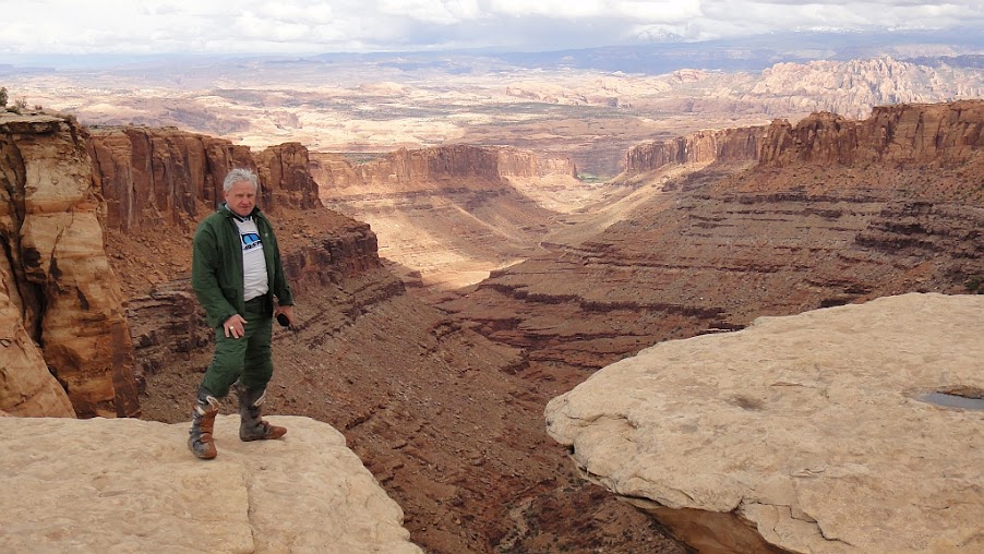
I even got someone to take my picture, so you can see i was really there!


I had issued a disclaimer about murphy's hogback.  One time, it had some big steps, & was a tough climb.  Another time, it had been graded & was easy.  I did not know which would be there when we got there.  But at every stop, someone wanted to know how much further it was..  it was almost like going on vacation with kids.. 'Are we there, yet?' every so often.  It was a mild distraction, but i was enjoying the views & the ride.


The riders:  Chuck, Bob, me, Mark, Cliff, Kim.


The bikes: Mark- klx250, Chuck- Kawasaki Versys, Me- yamaha 250, Bob- klx250, Cliff- klx 400, Kim- klr 650.  All Kawasaki's except for the lone little yamaha!


But the views were always spectacular, & you are overwhelmed by the distances.
We were nearing murphy's hogback.. a high plateau with panoramic views.


The climb up murphy's..


This is Chuck riding up the steep climb to murphy's hogback.. no issues.. good road.


The view from the top:


The descent can be tricky, too, but the rain gave us nicely packed down dirt.. good traction, no slipping.


This is the last of my videos.. my battery ran down, & the rest is pretty much the same, except for the views along the colorado river.  But those are in a previous year's ride report, if anyone wants to see them.


Some of the riders were getting tired.. 'how much longer?' became more frequent.  So i stopped less for pictures, & picked up my pace a bit, even though i always had to wait a bit for the others to catch up.  Kim & Mark were excellent riders, & Kim rode sweep, to make sure there were no mishaps or lost riders.  But the purpose of this ride was to enjoy the scenery & the ride, not to race or set a time record.


Here's Bob with the 'white' rim in the background..


Kim, riding sweep:


Cliff, Bob, & Kim, coming down the trail:


When we got to the shafer trail junction, Chuck had been studying a map.  He thought it would be less dirt to go up the shafer trail to the top of canyonlands, then take the highway back.  There was ~ 12 miles of dirt to the potash road, & another 20 back to moab.  We debated for a bit, but most riders wanted to continue along the potash ponds, & see the views along the colorado river.  I volunteered to take Chuck up the shafer trail, but Kim vetoed it, & told me to go on.  The road wasn't that rough from here on, & there were few hazards, other than a few puddles.  We made it back to moab by ~ 6:30, & everyone stumbled to their rooms.

The white rim trail is still probably my favorite overall ride.  I like the grand canyon rides & many other regular ones, but the WRT has it all.  When you add some human drama, it completes it.  It distracted a bit from the ride, but anytime you ride with others there will be some personality issues.  That was one of the things i liked riding with just Kim & Tom.  We seemed to be on the same page, and didn't have any unmet expectations or disappointments.  I guess i prefer smaller riding groups for this reason.. 3 or 4 seems to be about the max you can have without drama or dissappointment, but even then it depends on the riders.  I suppose my group riding days are winding down, anyway, & i doubt i'll volunteer to 'lead' anything like this again.  I was always having to think about the trail.. was there a way through the mud?  Is it passable for everyone?  Will someone crash & get hurt?  There were some mild sections that weren't really that tough, but i had to worry if all could get through, & look for a line that made it easier.

I'm sure in a few weeks, i'll forget all about the personality issues, & remember only the ride.  That is why we do it, anyway.

6/10/12

Grand Canyon 2012


I'll set the stage first.

Tom, from prescott, is riding a honda 650 xrl, &; 2 of his riding buddies from California came over to ride with us.  Terry, also on a honda 650xrl, &; Bill on a honda 650xrr.  Kim &; i are in sedona.  Kim is riding a kawi 250, &; i'm on a yammie 250wrx.  All are moderate to excellent riders, the youngest is pushing 50, &; Tom broke 70 some time back.

Tom, Bill, &; Terry ride over near sedona.. mostly on dirt, &; we head up stoneman lake road, &; go through mormon lake &; wynona ranch road up to flagstaff.

Up near mormon lake, it is near 7k ft elevation, &; it is nice &; cool in the pines.  Here are Kim, Terry, &; Tom coming down the road.

Photobucket

Wynona ranch road is where the boulders begin, &; the road gets interesting.  We had a few gnarly spots on the way, but they start increasing in intensity here.

Terry is leading the way here, picking out a safe line through the boulders.


Wynona ranch road is a  great day ride that we like to do at other times during the year.  It makes a great inclusion in the grand canyon ride.  It's not too long, or too rugged, but is challenging &; scenic.. &; it's on the way to grand falls on the rez.


We gassed up &; had a snack when we got to flag, then continued on up leupp road toward grand falls.. aka, chocolate falls.  There would be no falls today.  The road to grand falls was sandy, wide, washboarded, dusty, &; fast.  Tom passed all of us &; got to the falls first.

Here are the riders:  Me, Kim, Tom, Terry, Bill.  Behind us is the mighty grand falls.  This is the little colorado river, &; here it is mostly a spring runoff from the white mountains in central eastern az.  It also flows during summer monsoons.

Photobucket


We took another short break here, then continued along reservation roads to cameron.. about 40 miles through sandy washes &; long flat roads.

Photobucket

We saw some wild horses in the distance, but since they have spring foals, they usually don't come close.  They are hunted &; caught by the Navajos, &; stay away from humans.  Very rarely we've seen them within a hundred yards, crossing the road, or galloping up into rocky heights.

Photobucket


This section of the ride is one of Tom's favorites.  If we dare suggest another route, he would pout for weeks, so we now consider the ride through grand falls as essential to the grand canyon destination.  It is a fun ride.. the roads are sandy, there are some washes you have to go through, &; some rocky sections to keep you alert.


We very seldom see any vehicles here, but we did cross paths with an advrider on a yamaha going the other way.. but neither of us stopped to chat.  There are a few older hogans, &; some inhabited trailers &; small homes that the ranchers live in.  But it is  very isolated.  You feel a long ways from civilization, which is what we want.

Photobucket

Photobucket


There were a few spots where the sand got deep or blew over the road in long heaps.  If you kept your speed up, they weren't a problem.

Eventually we made it to cameron, where we would cross the little colorado river again.. this time over a bridge.  We would double back to gray mountain, where we connected with the gray mountain truck trail, another fantastic road going the way we wanted to.  This was still on the Navajo reservation, &; was a very rugged road.. lots of rocky climbs, turns, dust, &; more wild horses.

Photobucket

The gray mountain truck trail mostly climbed up to 7k ft.  We dropped below 6k at cameron, but climbed again.  The views were long, &; it was still very sparsely populated.  There is one ranch early on the gray mt trail, but none after that.

This clip has a short view of some horses galloping over a ridge at the beginning.


About 1 minute into the next clip, there are some more wild horses crossing the road in front of me.. a mare &; her colt are on the left, not being able to cross in time.


At the very top, you can see the little colorado river canyon below.  This is the same river that we crossed at grand falls & cameron.  We would see it again in a few days on the cape solitude ride.

Photobucket

We came down the switchbacks, and proceeded down pavement for a few miles until we came to another dirt road.. a blue-gray gravel improved road.  Not far to the grand canyon lodge, now!


These videos are all in high def, so you can switch them if you have a fast connection.. it makes the rocks bigger & the offroad look tougher.  Mostly it increases detail, so you see things better.

Coming down the switchbacks to hwy 64.


Fast & dusty on graded gravel.


We came from the east, & followed what used to be a nice dirt road.. we seldom saw any cars on it, but for some reason, the park service felt the need to grade it & dump loads of blue gray gravel on it, which made it very dusty.  We had to spread out a lot on this road.  But eventually it brought us into the park, & we rode to the village & checked into our hotel.  Notice the difference in vegetation between the last video & the next one.  We start getting into pines again, as the elevation gets back up around 7k ft.


Photobucket

Some of us split a pizza, had some beers, & watched a basketball game on the bigscreen.. no camping/roughing it for us!  I had been turkey hunting & camping with my son for the previous 4 days, & this was the lap of luxury for me!

But no trip to the grand canyon is complete unless i get to stop by & visit my mule friends.. they always listen attentively, nod to me with understanding, & are very sympathetic to all my troubles.  The other guys don't seem to understand the deep spiritual connection i have with the mules.. plus they like the apples i bring them.

Photobucket

Kim & i got about 150 miles in.. the other guys added about 80 more.  The roads were long & dusty, but we made it without any real trouble.

end of day 1.

Photobucket

Day 2.

Tom's shoulder has been troubling him.. he had tommy john surgery on it a while back, but he still can't throw fastballs, or ride very long.  Terry, too had not ridden much in the last year, so 2 long days of riding were enough for him.  Kim was glad to have the other guys make excuses, so he would stay with them.  That left Bill & i to ride this day.  We met at the maswik cafeteria & had a hearty breakfast, then we suited up & left the sissies to sachet around the park while the real men went on a ride.

Bill was low on gas, so we rode out on the dirt to tusyan & gassed up.  Then we ran down some very dusty roads until we got near the rez.

We rode out to the west.. toward the havasupai reservation, but stopped short of there & cut through some nice 'almost' single track.  These roads were pretty tight, & snaked their way through the woods.  Bill doesn't get much of this kind of riding in s. Ca, so it was a nice change for him.


We got some dead ends.. i hadn't ridden this in a few years, but we eventually found our way through.

Along the way, we came across the same old truck that Tom & i had seen a few years back.. it is on a very remote, rugged road, so hadn't changed much that i could tell.  We think it is an old dodge, but there are no markings.  The story behind it is when Tom got out of the rough riders, he came out west to watch over the grand canyon for Teddy.  When motor vehicles became available, he picked up this truck to ride out to the rim & watch for poachers or squatters.  Anyway, here is Tom's old truck:

Photobucket

The destination overlook was near the bass trail head.. some  cool views to the west.

Photobucket

Photobucket

We took a break here, then headed for an old fire tower.  Not really grown up yet, we could not resist the urge to climb up it & look around.

Photobucket

Photobucket

Bill was able to get a faint cell phone signal, so made the best of it by sending a picture of the views.  It took a while, but made it.  We climbed down & continued our adventure.

A few years back, Tom & i had ridden a road south from the tower, but it kinda disappeared.. we lost it & found ourselves wandering in the trees & brush until we could make it to a little more recognizable road.  This information did not deter Bill in the least.  He wanted to see if we could get lost, too!  Armed with his trusty gps, showing very little information, other than were were in az somewhere.. we headed across the remnants of a road.

This is long.. for my clips.. over 10 minutes.  I include all of it as proof that we didn't get lost, nor wander for days in the scrub pines & chaparral.  Bill was able to see time worn remnants of a trail, & he stayed on it.


The dirt roads on this side were very rutted.  You had to be careful in those or they would pitch you over the side of the road.  It was also quite dusty, & we took turns riding point.  My gps had gotten a glitch, & i lost my topo maps & some other reference points.  All i had was some way points on a blank screen.  There were a lot of roads criss crossing & going every direction, & many were not on the map & none were marked.  We found a gate back into the park.. we had been out of the nat park for a while.. & followed a bee line road back to the village.  It had some rocky sections.. some nice steps & ups & downs, but nothing we couldn't handle.  We were back in town by mid afternoon.  We sauntered over to the ice cream shop & indulged in 2 scoops of dryers finest.  ..not a bad lunch, but we'd need dinner in another hour or so.  Tom missed his long island iced teas, so we stopped at the bar & Bill bought everyone a round.  We drank to his generosity, & then staggered back to the rooms, it being almost dinner time.


Terry was back from being a tourist, & we all went back to the cafeteria, then back to the rooms where Kim, Tom, & i watched another playoff game in basketball... well.. i made it to halftime, then drifted off.

End of day 2, for me..

Day 3.  The search for solitude.

This is the highlight of the ride for me.  The destination was Cape Solitude.. at the confluence of the colorado & little colorado rivers.  It is a long, rugged ride, starting in the park, then going into the rez, then back into the park.  We go from pines to sage & grass.  We have steep, rocky switchbacks, long sections where the road almost disappears, & a few turnarounds & backtracking.

We start early, since it will be a long day.  We grab some breakfast at the cafeteria, then head out toward the desert view tower at the far end of the park.  It's about 30 miles through 7-8k pine covered roads, & at 8am it's pretty chilly.  There are 4 of us, as Terry had to go back home this morning.  He left earlier than we did, to get a jump on the long ride.

Some of my videos don't have any sound.. my camera is getting old, & i guess dust has gotten in & makes a bad connection with the mike.. not a big deal.. you can only hear motor & wind noise, anyway.  Also, remember to change them to high def if you've got a fast connection.. the detail is better.

We got to desert view, gassed up & started down the switchbacks.  Some of these are pretty rugged.. rutted out, loose rocks.. tricky riding, but we all made it ok.  This first section is one of my favorite view rides of all time.  You ride along the rim of the grand canyon, with killer views at every switchback.


Then we head away from the rim, toward the reservation.  The vegetation starts to get more sparse as we descend in elevation, & things open up in the distance.  But the roads stay pretty rough.


By now, we're on the rez.  ..very few ranches.. sometimes we'll see wild horses, but not this time.  We go for miles & hours through these rough, lightly traveled roads.  Very few people get out to the cape.  Near the 4 minute mark in this video, i go off the road on a steep climb, & have to get reorganized to get back on track.


There are some pretty steep, rocky sections, with high steps in them.  You'll go down one, then up the next.  We take few breaks, but we have a long ride ahead of us, so you never get much of a break.. the road is always bringing up a new challenge & something you need to be alert for.


I'm still having some problems with my maps.. i had some nice topos loaded, but they got glitched out somehow, so all i have is the regular maps that come with the unit.. they show some dirt roads, but not all of them.  They also show some roads that aren't there.  I follow one of those roads to a gated fence.  We get through it, but the road disappears & we have to turn back.  We get back on track after a short side detour..  There are 2 really big, steep, rocky climbs we have to do before we get to the cape.  This is one of them.  I have to stop at the top & let my heart catch up with the rest of my breathing.


By now, the road is less traveled.  It is clearly marked, but no vehicles have been on it for a while.  We still are winding around, going up & down some pretty steep, rocky sections, but the destination is worth it.


There is one last climb.. possibly the gnarliest one.. that we have to go up before we reach the cape.  I try to keep my speed up, because i remember it from before.. very steep, lots of steps, loose rock.. all the things that make riding this fun.


We finally climb the last rugged section, & have a little bit of easier riding for the next few miles.  Here's where the views start to open up, & glimpses of the canyon come to view.  This is what we came here for!  The long ride has finally brought us to our destination.  We have found Solitude.  Cape Solitude.


Cameras just cannot capture the grandeur of these views.  We were all awestruck by the distances & both rivers below.  The little colorado is turquoise green, from travertine in the water upstream.  It is very cool.

Photobucket

Photobucket

I this shot you can see both rivers coming together.. the next picture shows the confluence.
Photobucket

Photobucket

Photobucket

Here are the riders that made it to solitude:
Photobucket

We stopped for a snack.. stared at the vast expanse, & pondered the meaninglessness of the other guys' existence.  But we knew we'd have to ride back, eventually, & there were ominous looking clouds in the distant southeast.  We got ourselves psyched back up & headed back the way we came.

I didn't take any more videos, and we didn't have any significant problems to record, anyway.  No one crashed, had bike problems, ate a big sandwich, or any other photo worthy event.  We just bounced along on the bikes & returned the way we came.

But we didn't go back up the switchbacks by desert view.  No, we went up the infamous gray mountain truck trail.. this time from the north side of hwy 64!  My camera ran out of juice, so i was not able to record this groundshaking event.  But we did stop at an old hogan.  Bill got closer for inspection.

Photobucket

At the top, we came back to hwy 64 & most decided to head back on pavement, through the park.  But Bill was not through with his adventures.. He followed a dirt road, missed a turn, then followed another until he got back on the blue gray gravel road we came in on.

We were tired.. but went to the cafeteria for dinner.  No one wanted to sit in the pizza bar to watch tv, so we walked over to the market & bought a 6 pack to take back to the rooms, where soft beds & easy chairs awaited.

End of Day 3.

Day 4 was uneventful.  We had breakfast, then Tom & Bill rode back on the pavement to Prescott, while Kim & I took the pavement through Flag back to Sedona.

1/24/12

Oct. 2011 Utah ride, Moab white rim trail

Tom & i got up early, had a nice breakfast at the hotel, then rode out of moab to the white rim trail. We went along the colorado river, then past the potash ponds to the trail. We were hoping the road was open & we could do the full loop.

It was a chilly morning, but as the sun rose it warmed for us. We had no bike issues, & the sky was pretty clear.


We stopped at Musslemans arch.. Tom is demonstrating how he would ride across it, if they would let him.


The scenery along the white rim trail is fantastic. Next to the grand canyon, this is my favorite view ride. But the white rim ride has everything.. rocky switchbacks, wash crossings, long sandy stretches, etc. It is challenging, scenic, & without a doubt one of the best motorcycle adventure rides out there. You can do it in a day, & there is more to see than you can remember.


The audio got lost in this one.. my contour hd camera is having some technical difficulties.. sometimes the audio does not get switched on.. not a big deal, the audio is pretty useless. All you hear is motor & wind noise. But it does add to the video effect.

You can see by the long shadows that it's still pretty early in the ride. We hadn't gotten to the 'white rim' yet.


If you've got a fast connection, turn up the resolution on the videos. I recorded them in HD, and the detail is better if you can download it. In this clip, we come up on the edge of the rim. The whitish colored rocks along the edge give the trail it's name.


It is mostly rocky in the first part, with a few bits of sandy roads sprinkled in. There are also some switchback sections, where it is loose & sometimes stepped.


Every so often there are some very cool rock formations.. it is amazing how they can form from just wind & water.


We came upon this little section.. it had a rocky section.. a little steep, but nothing too bad.. i just got on the wrong side of the trail & bounced off. I landed on my feet like a cat & let the poor bike crash by itself. I picked it up, rolled down the hill & came up with no problems on the second try. Tom just yawned as he rode up it.


This is the section of trail that goes up to murphy's hogback. It sometimes is very loose & torn up from use, which makes it more difficult on a bike. It wasn't too bad this time.


The views from on top are always magnificent.


After another climb, we start following the green river & get down to the sand. We try to keep our speed up.. the sand is very dry & loose, & a bit of speed helps to get through it. It was very dusty, & whoever was following had to let the dust settle a bit or you couldn't see the road. This is a long clip. It also has a climb through some rocks, follows along the cliff, then goes back down to more sand. It was a little steeper, had more turns, & was looser, and longer than the murphy's hogback climb.


This is the final section winding along the cliffs above the green river, then heading back down into the sandy valley. The sand along here was the worst, & was very loose going down the switchbacks. This is another longer clip, but has great views along the river cliffs, & has some interesting riding terrain, too.


After this, we had few climbs until we get to the big switchbacks at mineral bottom road. But we still had lots of sand.. i rode behind, & the dust was so bad i couldn't get any videos. It was nice along the river, & several times we were just at the water's edge.


This was the final climb on the switch backs that got washed out a couple of years back. They had only been finished for a short time, & of course the riding was smooth & easy.


We got up on top, took a wide graded road to some pavement, then rode the rest of the way back to moab. Dinner, cold beer, & back to the room for a rest. Tomorrow, we head to hanksville!

Scotty's info

My photo
Sedona, Arizona, United States
Semi-retired home builder. Musician. Former adventure rider. Philosopher. Innovator. Tech freak, genealogist, golfer. Cosmic Watcher.